1. Introduction
An early task in the Wisconsin Department of Transportation (WisDOT) TOPMS project was to compile a summary scan of internal data sources that have at least some potential bearing on traffic operations performance management. The scope of this task does not include detail on the many and varied sources of data from other providers, although some are mentioned below for completeness. This data sources inventory is intended to be a living online resource not only for the TOPMS project but for use by others.
The organization of this begins with a summary table, followed by brief descriptions of each source within data type categories. Use the table of contents at right to skip down to a section of interest.
Chief among the resources available to obtain traffic operations data is the WisTransPortal transportation data hub. Hosted by the Wisconsin TOPS Lab, this is the central source for traffic operations, safety, and intelligent transportation systems (ITS) data, archiving, and real-time services for Wisconsin highways. Because of its prominent role in this performance management project, unfamiliar readers are encouraged to first familiarize themselves with some basics about the WisTransPortal by starting here: About WisTransPortal.
Those interested in learning more about where ITS devices and communications are located through the state should start at Wisconsin ITS Inventory.
All questions, corrections, and suggestions related to this page should be directed to inventory@topslab.wisc.edu.
2. Summary Table
The following is a summary table of the sources described in more detail below.
[table id=21 /]
* password required, see below for more info
3. Data Background
Data Standards
To the greatest extent possible, The Wisconsin TOPS Lab develops all systems, databases, and data feeds to industry standards. Some of the most pertinent ones are mentioned here.
- National ITS Architecture. See Wisconsin ITS Architecture.
- ITSA ATIS Data Quality Guidelines.
- SAE J2354 ATIS Message Set Standard.
- AASHTO-ITE Traffic Management Data Dictionary (TMDD).
- IEEE Incident Management 1512 Standards.
- Applicable State of Wisconsin and WisDOT IT standards, particularly for any components either hosted by WisDOT or that interoperate directly with WisDOT or TOPS Lab IT systems.
- Location Referencing Message Specification (LRMS).
- The National Transportation Communications for ITS Protocol (NTCIP).
Data Geography
The foundational geographic basis for almost all traffic operations data originating from WisDOT is the State Trunk Network (STN). The STN includes all interstates, other freeways, expressways, and other State Trunk Highway (STH) routes in Wisconsin. It does not encompass county or local roads. The STN has a strong geographic information system (GIS) basis, with both a chain and a link-offset representation, access point and landmark locations, and other core attributes. In addition, many data sources are built upon STN, many of which are described below. These include MetaManager and its multiple components; the Wisconsin Lane Closure System; the Highway Performance Monitoring System (HPMS); and much of the 511 traffic data, including incident locations, closures, and winter road conditions (by 2014).
The Wisconsin Information System for Local Roads (WISLR) is a second GIS basis for roadways in Wisconsin. Although the coverage is more expansive than the STN to include local roads, it lacks some of the core GIS and linear referencing features that STN offers for operational data. More information: WISLR.
The Traffic Message Channel (TMC) is a world wide standard arising from FM radio broadcasts of traffic conditions. This is a geographic basis used by many private data providers, including TomTom (TeleAtlas) and HERE (Nokia-NAVTEQ). WisDOT and the TOPS Lab have experience with TMC-based data sets from both TeleAtlas and NAVTEQ, and this will be the mapping basis for the forthcoming FHWA probe data, described below.
4. Data Sources
Traffic
These include sources providing information on volumes, flows, speeds, occupancies or densities, forecasts, and levels of service (LOS).
FHWA NHS Probe Data
The Federal Highway Administration (FHWA) has acquired a National Performance Management Research Data Set (NPMRDS) of average travel times for use in performance measurement. This data set is being made available to States and Metropolitan Planning Organizations (MPOs) as a tool for performance measurement. This is made available through the Freight Performance Management (FPM) and Urban Congestion Relief (UCR) programs. The data are furnished by Nokia’s HERE business unit (which encompasses NAVTEQ), and consists of the following:
- Average travel times;
- Five-minute bins;
- National Highway System (NHS) coverage, namely interstates and US highways;
- By traffic message channel (TMC) links;
- By passenger, freight (5+ axle, class 7-8 per ATRI), and combined;
- With GIS shapefiles;
- From October 2011 to present, updated monthly; and
- On a state by state basis, with a usage agreement required.
The data are available as of October 2013. The TOPS Lab is supporting WisDOT in the understanding and use of the data, including performance metrics and mapping. Visit the GLRTOC website for several examples. More information on accessing this information is on the WisTransPortal.
MetaManager
The MetaManager is a WisDOT data management system built upon the State Trunk Network (STN) GIS that integrates a wealth of data across many functional areas. MetaManager is heavily utilized throughout WisDOT for asset managment, performance management, conditions monitoring, investment decisions, planning, and other The information is refreshed three times per year and distributed in April, August, and December. Requests for this data should be directed through your WisDOT project contact.
There are approximately 23 thousand MetaManager segments, averaging 0.6 miles in length, ranging from very short (~50-foot minimum) to 5.75 miles. The majority of segment lengths are within 0.2 to 1.0 miles. Segments are categorized in many different ways, including by divided (directional), undivided (both directions), and one-way.
The total centerline mileage of the coverage includes approximately 740 miles of interstate, 420 miles of other freeways, 480 miles of expressway, and 10,130 miles of other routes (90% of which is undivided).
MetaManager data is bundled into the following sets:
- Base data, which integrations locations among different sources,
- Roadway data, comprising AADT values and certain physical attributes of the roadway such as curves and no-passing zones,
- Pavement data, for pavement conditions such as distress and roughness, as well as needs analyses,
- Safety data, see the description in the safety section below,
- Bridge data, with attributes and current and projected conditions,
- Mobility data, described here.
The mobility data in MetaManager has four main components.
- Level of service (LOS), for each traffic segment, for the next 20 years (five-year increments),
- Identified deficiencies for segments exceeded defined thresholds,
- Suggested improvements in passing lane corridors, and
- Suggested improvements for routes with seasonal deficiencies.
The mobility data also includes many attributes from related sources, e.g., projected AADT from the Traffic Forecasting section, posted speeds from Cartegraph SignView, etc.
Private Data Providers
- Inrix, including real-time data and analytics: Inrix.
- Nokia-NAVTEQ-HERE, excluding the FHWA NPMRDS described above: HERE.
- TomTom, real time and historical traffic: TomTom.
- TrafficCast, including public sector services and Dynaflow.
TRADAS
Since 1993, archived hourly volume count data are available through WisDOT’s TRAffic DAta System (TRADAS, a product from Chaparral Systems). TRADAS is managed by the Bureau of State Highway Programs. It houses continuous (e.g., from fixed automated traffic recorders (ATRs) and short duration (e.g., pneumatic tube counts) volume, speed, and vehicle classification data.
The data cover tens of thousands of locations around Wisconsin, housed in an Oracle database, and accessible in a number of ways.
- Summary excerpts are available to WisDOT staff, with additional reports available through an interface called RoadRunner.
- Traffic count maps, as PDFs from 2000-2010, and more recently via an interactive map, available here: WisDOT Traffic Counts.
- Tables of hourly counts, by month, averaged by day of week, are available here: WisTransPortal Hourly Traffic Data. This page also contains a very good summary of the data collection and reporting processes.
V-SPOC
WisDOT operates around 4000 real-time traffic detector locations – mostly inductive loop detectors, but increasingly microwave detectors. The coverage of these detectors, which operate through the Statewide Traffic Operations Center (STOC) Advanced Traffic Management System (ATMS), are largely in the Milwaukee area, to a lesser extent in Madison, Fox Valley, and other locations. Detailed maps of the controller locations are available upon request. The coverage is approximately reflected on the Wisconsin 511 map as well, for example, Wisconsin 511 map showing taffic speeds.
All data from these detectors from 1997 to present are archived in 5-minute bins by the Wisconsin TOPS Lab and made available via the WisTransPortal Volume, SPeed, and OCcupancy (V-SPOC) application. A summary of V-SPOC is here: WisTransPortal V-SPOC information.
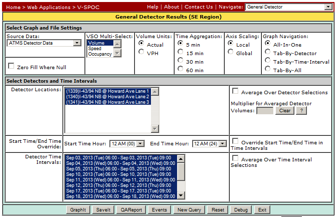
The application also provides the users with graphical summaries and a wide variety of other utilities. A WisTransPortal login is required to access the data. Larger or more complex queries are available through TOPS Lab staff.
Crashes
These include sources providing information on crash rates, crash severities, and specific crash data.
MetaManager (crashes)
Refer to the general MetaManager description above.
The crash data provided as part of MetaManager are the results of a processed, systems-level analysis. Every mile of the STN is assigned one of twelve functional peer groups, and baseline statistics are applied to each group. In addition to crash counts and rates, summaries are provided by a selection of classifications, followed by a selection of indicator flags for relatively higher crash occurrences of different types. A second set contains spot analyses from a rounding and aggregation process.
MV4000 Crash Data
MV4000 refers to Wisconsin DOT’s motor vehicle accident report. the WisTransPortal is the primary point of access to the crash data archive of all reported crashes in Wisconsin from 1994 to present. Learn more and access the archive here: WisTransPortal crash data.
Safety Data Portal
 Though no longer available, there previously existed a Wisconsin Safety Data Resource Portal that provided comprehensive information about a wide variety of data sources both central and related to crashes and safety. Several of the data sources summarized here on this page were also described in the safety portal. The portal had been sponsored by the WisDOT Bureau of Transportation Safety.
Related Sources
Road Weather
There are two primary types of information on road weather conditions in Wisconsin. First is the segment conditions as reported by the Wisconsin State Patrol (WSP). These are actual field observations, updated several times per day, or more frequently if conditions are changing. The coverage is most primary routes in Wisconsin, with about 120 fairly fixed segments (varies slightly between each season). The coverage is shown on the Wisconsin 511 map at Wisconsin 511 map showing winter road conditions. The page WinterRoads.info also provides alternative views. Unfortunately there is currently no data feed available, nor is there a usable archive available. By about January 2014 the vendor-provided system that WSP uses is being replaced by a new application that is part of the WisTransPortal call the Winter Roads System (WRS). When that change occurs, winter road conditions will be provided via real-time XML, and all conditions will be archived for multiple purposes later. This subsection will be updated when that happens.
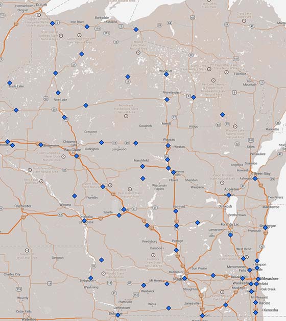
The second type is a set of point observations from environmental sensor stations (ESS) that are part of Wisconsin’s Road Weather Information System (RWIS). As of September 2013 there are 65 ESS locations statewide, shown on the map below. The locations will be available on an interactive map in the future.
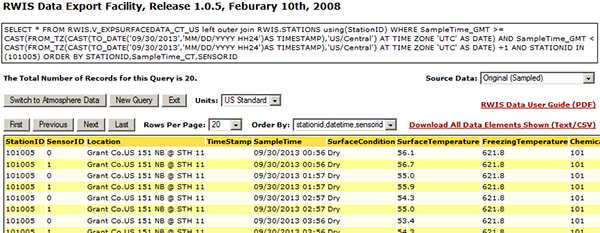
Until the middle of 2013, WisDOT provide a real-time RWIS map on their website, but that is not longer available. The Clarus initiative was a nationwide portal for RWIS data, but that is currently being transitioned to NOAA’s MADIS (more info). Nonetheless, the WisTransPortal provides tabular RWIS data from 2006 to present via a web interface query tool. A WisTransPortal login is required, then access that at WisTransPortal RWIS data.
The data are updated every 30 minutes, and current tabular views for atmospheric conditions and road weather conditions are provided. The site also provides a very good user guide with complete descriptions of all the available fields. Atmospheric conditions include temperature, wind, humidity, pressure, visibility, and others. Road surface conditions include surface temperature, subsurface temperature, moisture characteristics, and more.
Incidents and Closures
The WisTransPortal also houses data on incidents and lane closures. Incident data includes the following two resources:
- The InterCAD Database, where the InterCAD system is for real-time data exchange between law enforcement and traffic operations, the data is archived and available through an online interface. A WisTransPortal login is required: WisTransPortal InterCAD data. The archive is from 2009 to present, and the data available include many attributes but no personally identifying information.
- Traffic Incident Alert (TIA) System, which provides a mechanism for distributing email alerts and media releases, and makes available an archive of the higher impact incidents and events that generate a TIA. A WisTransPortal login is required: WisTransPortal TIA system.
All lane closures on WisDOT facilities are entered into the Wisconsin Lane Closure System (WisLCS), also a part of the WisTransPortal. In addition to being a tracking and approval system, all closures are archived. More information is available here: WisTransPortal WisLCS. A WisTransPortal login is required to access the archive. Closure information includes detailed location, description, dates, and times. The WisLCS data is also provided in real-time via XML (see below).
Real-Time XML
Two XML feeds provide the majority of the ongoing real-time traveler information. Requests to access these should be directed to WisDOT STOC by email, and this will ensure you receive the latest information and future updates. Associated ITS inventory locations is available from the TOPS Lab, also by email.
Please be aware that to view any of the links below, you need an unzip utility, e.g., right click links to save, then unzip using any desktop unzip utility. Developers will automate this with scripting via Python, Perl, Java, etc.
-
Wis511 XML feed, is updated every minute and includes information on incidents, link speeds, segment travel times, and dynamic message signs.
Available at Wis511 XML GZIP
-
Wis511LCS XML feed, is updated every ten minutes and includes information on lane and road closures.
Available at Wis511 LCS XML GZIP
-
A third source is for winter road conditions as part of the Wisconsin 511 Winter Roads System (WRS). The links below are connected to the data coming from the WRS application and contain live data as of December 11, 2013. The inventory contains the segment attributes and geometry (as a series of long-lat values) and is updated as segments change (rarely). The conditions are updated as often as every minute if changes are entered, but refreshed no less frequently than 10 minutes during winter.
WRS Inventory: 511 WRS Segment Inventory XML GZIP
WRS Conditions: 511 WRS Segment Conditions XML GZIP
There also exists a separate internal special events XML as part of WisLCS, updated nightly.
Specific Projects
There exists a wealth of traffic data that is collected by individual project or study efforts, but that is not captured in any central database. For these, inquiries need to content.dot.wipropriate WisDOT staff or the consultants involved. A prominent example of this is the Madison Beltline origin-destination (OD) study completed fall 2012 in Dane County, utilizing 120 Bluetooth detectors over a six week period, resulting in several million OD pairs, accurate and rich travel time data, and trip routing detail.
Cameras

WisDOT operates over 300 cameras statewide for monitoring traffic conditions and assisting with incident response. These cameras are controlled at the STOC, but outside the control room there are a few ways to see the views.
- Still images, updated every three minutes, are available through the WisDOT webservers. For example, at right is a live view of cam031.jpg (click the image to see the example link). For a complete list of cameras and URLs, see the introduction for the ITS Inventory link or email contact.
- The Wisconsin 511 traveler information website displays most of these images on the interactive map, for example, Wisconsin 511 map with cameras.
- The LINK service provides real-time WisDOT freeway camera video, incident reports, event information, and freeway travel times to members of the Traffic Incident Management Enhancement (TIME) group and others. Video is set up as fixed tours along certain corridors, and not all cameras are available. Access at WisTransPortal LINK System, and login is required to see video.
DMS
WisDOT operates many dynamic message signs (DMS) statewide, about 85 of which are shown on the 511 website (click here to view map, then hover or click over a DMS icon to see the contents). Messaging often includes current travel times by default, with incident or lane impacts displayed as needed. On occasion, select DMS are used for safety messaging, e.g., Buckle Up. A list of DMS is available via the ITS Inventory, noted in the introduction. Queries about the DMS message history can be requested through the STOC control room. With an identified start date, all messages displayed would be summarized, with durations.
5. Other Agencies
In many cases, traffic information outside Wisconsin is relevant to Wisconsin’s traffic operations performance. Some options follow for accessing operational data from each neighboring agency.
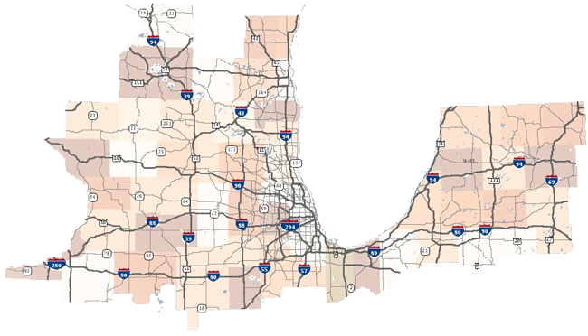
GTIS
The Gateway Traveler Information System (GTIS) is developed and hosted by the University of Illinois at Chicago. In partner ship with Lake Michigan Interstate Gateway Alliance (LMIGA) agencies, GTIS serves as the central real-time traffic data portal for Illinois and the surrounding region. The current geographic coverage is shown in the image below. Visit TravelMidwest.com to see more.
Neighboring States
These are just links to neighboring traveler information resources to give you a sense of the traffic data and coverages available. More information is available by contacting the TOPS Lab.
Illinois DOT
Illinois Tollway
Iowa DOT
Michigan DOT
Minnesota DOT
National Data
Many other sources of transportation data are available at the national level. This WisDOT page has a comprehensive list: WisDOT Transportation Statistics.